Файл:WorldCenterOfPopulation.png

Исходный файл (1073 × 661 пкс, размер файла: 141 Кб, MIME-тип: image/png)
Описание
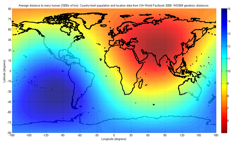
| Описание | The figure indicates the average distance to every human on earth, depending on location. The population and location data used are at the country-level, from the 2008 CIA World Factbook. The distance was computed first by finding the geodesic (shortest path) distance along the surface of the WGS84 reference ellipsoid to each country on the list, and then finding the weighted average of all such distances with the weight being the corresponding country's population.
I have used only publicly available data for this image. The image may look slightly different in future, as world population distributions change. The image will also look different if a different distance metric is used, such as a Euclidean distance in three dimensions, which would allow for tunneling through the earth. |
|---|---|
| Источник | Own work |
| Время создания | 2008-06-02 |
| Автор или правообладатель | Brhaspati — Лицензия: CC BY-SA 3.0 (Creative Commons Attribution-Share Alike 3.0) https://creativecommons.org/licenses/by-sa/3.0 |
| Другие версии файла | — |
Источник файла — сайт Wikimedia Commons, куда он был загружен под одной из свободных лицензий ( https://commons.wikimedia.org/wiki/File:WorldCenterOfPopulation.png ). Авторов, работавших над этим файлом см. в истории файла: https://commons.wikimedia.org/w/index.php?title=File:WorldCenterOfPopulation.png&action=history
В общем случае в статьях энциклопедии Руниверсалис файлы используются в соответствии со статьёй 1274 Гражданского кодекса Российской Федерации.
История файла
Нажмите на дату/время, чтобы увидеть версию файла от того времени.
| Дата/время | Миниатюра | Размеры | Участник | Примечание | |
|---|---|---|---|---|---|
| текущий | 15:27, 22 января 2024 | | 1073 × 661 (141 Кб) | I, Robot (обсуждение | вклад) | == Описание == {{Изображение | описание = The figure indicates the average distance to every human on earth, depending on location. The population and location data used are at the country-level, from the 2008 CIA World Factbook. The distance was computed first by finding the geodesic (shortest path) distance along the surface of the WGS84 reference ellipsoid to each country on the list, and then finding the weighted average of all such distances with the weight being the corresponding count... |
Вы не можете перезаписать этот файл.
Использование файла
Следующий файл является дубликатом этого файла (подробности):
- Файл:WorldCenterOfPopulation.png из на Викискладе
Следующая страница использует этот файл: